- Cities and buildings
- Fields, plains and deserts
- Forests
- Hills and mountains
- Islands and promontories
- Lands, realms and regions
- Rivers and lakes
- Seas and oceans


 |
||||
|


Which personality type are you?
Take the Free mydiscprofile Personality Test to discover your core personality and your ideal job.   Which personality type are you? |
|
Dates
Created by the Music of the Ainur in ancient times; prophesied to be remade after the Last Battle
Location
Within the depths of Eä
Race
Pronunciation
a'rrda (the 'r' sound should be pronounced - 'rr' is used here to emphasise this)
Meaning
'Realm (of Manwë)'
Other names
Indexes: About this entry:
|
ArdaThe world
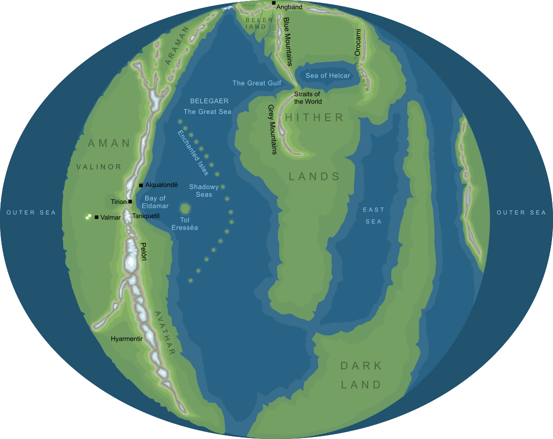
The shape of Arda before the end of the First Age (somewhat conjectural)1
The shape of Arda before the end of the First Age (somewhat conjectural)1
In the language of the Elder Days, 'Arda' signified the world and all that is in it. Arda was created through the Music of the Ainur to be a dwelling place for the Children of Ilúvatar (that is, Elves and Men). Originally a flat world, the continents shown in the map above were surrounded by a mighty ocean, Ekkaia or the Encircling Sea, and separated by Belegaer, called the Great Sea. In the First Age, the regions to the north and west of Middle-earth were occupied by the country of Beleriand, but this was destroyed during the tumults of the War of Wrath. In the Second Age, the isle of Númenor was raised in the Great Sea for the Edain to dwell on. This island existed through most of the Second Age, but was destroyed in the Downfall of Númenor as a result of the pride of the Númenórean people in defying the Ban of the Valar and sailing to Aman in the West. After the Downfall, the shape of Arda was changed, and it was made 'bent' (or 'round' as we should say in modern terms). Aman was taken out of the world, and could only be reached by the Elves, following the straight road that was granted to them. As Aman was taken away from Arda, new lands and continents were created. From the late Second Age onwards, the world began to take the shape that we know today. Notes
See also...Aman, Amon Uilos, Ancient Darkness, Arda Marred, Astaldo, Balrogs, Change of the World, Children of Earth, Children of Eru, Children of the Sun, Circles of the World, Cloud of Ungoliant, Culúrien, Dagor Dagorath, Dark Land, [See the full list...] Indexes: About this entry:
For acknowledgements and references, see the Disclaimer & Bibliography page. Original content © copyright Mark Fisher 1997-2000, 2008. All rights reserved. For conditions of reuse, see the Site FAQ. Website services kindly sponsored by Discus from Axiom Software Ltd.Discover how DISC fits together with our FREE and comprehensive Complete Introduction to DISC. |