The Encyclopedia of Arda - an interactive guide to the world of J.R.R. Tolkien
Dates
Númenor was established at the beginning of the Second Age, and destroyed in the Downfall of II 3319
Location
In the bay of Rómenna on the eastern coasts of Númenor
Race
Division
Culture
Settlements
Lay close to the harbour of Rómenna
Pronunciation
to'l ui'nen ('ui' as in English 'ruin')
Meaning
Island of Uinen (Uinen, the name of a Maia of the Sea, can be translated as 'watery weed')

Indexes:

About this entry:

  • Updated 2 April 2023
  • This entry is complete

Tol Uinen

An island in the bay of Rómenna

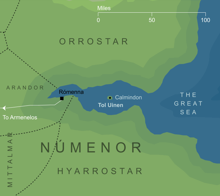
Map of Tol Uinen
Tol Uinen in the bay of Rómenna (somewhat conjectural)1

A small island that stood off the coasts of Númenor, in the long narrow bay of Rómenna that separated the regions of Orrostar and Hyarrostar. Legend said that the island had been placed there by Uinen herself, the Lady of the Seas, who was held in particular reverence by the mariners of Númenor. Indeed, the Guild of Venturers called themselves Uinendili - devotees of Uinen - and often moored their great ship Eämbar off Tol Uinen. Their Great Captain, Aldarion, raised a tower on the island named Calmindon, to shine a light across the waters of the bay of Rómenna.


Notes

1

We have no map showing the exact location of Tol Uinen, and all that can be said for certain is that it lay somewhere within the long bay of Rómenna. Rómenna was Númenor's most important port, and the channel leading to it would therefore have been busy with shipping. On that basis, the map shown here assumes that Tol Uinen lay in the widest part of the bay, rather than forming a hazard at the mouth, or near the port itself. The great vessel Eämbar was customarily anchored off the island, which further suggests that it lay well away from the most heavily used parts of the channel.

Indexes:

About this entry:

  • Updated 2 April 2023
  • This entry is complete

For acknowledgements and references, see the Disclaimer & Bibliography page.

Original content © copyright Mark Fisher 2004, 2021, 2023. All rights reserved. For conditions of reuse, see the Site FAQ.

Website services kindly sponsored by myDISCprofile, the free online personality test.
Take the FREE myDISCprofile personality test to discover your core personality and your ideal job.
Take the Free mydiscprofile Personality Test to discover your core personality and your ideal job.

Which personality type are you?

The Encyclopedia of Arda
Menu
Homepage Search Latest Entries and Updates Random Entry

Tol Uinen

An island in the bay of Rómenna

Dates
Númenor was established at the beginning of the Second Age, and destroyed in the Downfall of II 3319
Location
In the bay of Rómenna on the eastern coasts of Númenor
Race
Division
Culture
Settlements
Lay close to the harbour of Rómenna
Pronunciation
to'l ui'nen ('ui' as in English 'ruin')
Meaning
Island of Uinen (Uinen, the name of a Maia of the Sea, can be translated as 'watery weed')

Indexes:

About this entry:

  • Updated 2 April 2023
  • This entry is complete

Tol Uinen

An island in the bay of Rómenna

Map of Tol Uinen
Tol Uinen in the bay of Rómenna (somewhat conjectural)1

A small island that stood off the coasts of Númenor, in the long narrow bay of Rómenna that separated the regions of Orrostar and Hyarrostar. Legend said that the island had been placed there by Uinen herself, the Lady of the Seas, who was held in particular reverence by the mariners of Númenor. Indeed, the Guild of Venturers called themselves Uinendili - devotees of Uinen - and often moored their great ship Eämbar off Tol Uinen. Their Great Captain, Aldarion, raised a tower on the island named Calmindon, to shine a light across the waters of the bay of Rómenna.


Notes

1

We have no map showing the exact location of Tol Uinen, and all that can be said for certain is that it lay somewhere within the long bay of Rómenna. Rómenna was Númenor's most important port, and the channel leading to it would therefore have been busy with shipping. On that basis, the map shown here assumes that Tol Uinen lay in the widest part of the bay, rather than forming a hazard at the mouth, or near the port itself. The great vessel Eämbar was customarily anchored off the island, which further suggests that it lay well away from the most heavily used parts of the channel.

Indexes:

About this entry:

  • Updated 2 April 2023
  • This entry is complete

For acknowledgements and references, see the Disclaimer & Bibliography page.

Original content © copyright Mark Fisher 2004, 2021, 2023. All rights reserved. For conditions of reuse, see the Site FAQ.

Website services kindly sponsored by myDISCprofile, the free online personality test.
Take the FREE myDISCprofile personality test to discover your core personality and your ideal job.