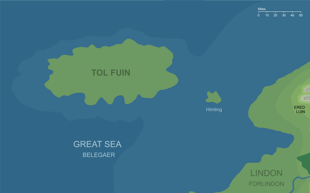
The island of Tol Fuin (somewhat conjectural)2
The island of Tol Fuin (somewhat conjectural)2
In the Great Sea off the northwestern coasts of Lindon in the farthest west of Middle-earth, lay the small island of Himling. This was a remnant of the First Age, being the surviving peak of the old fortified Hill of Himring. Westward beyond Himring a great highland region had risen during the First Age known as Dorthonion or Taur-nu-Fuin. After the Sea covered the lands of Beleriand at the end of that Age, the highest parts of Taur-nu-Fuin also survived as an island: Tol Fuin, out in the Western Sea beyond the tiny isle of Himling.
While Himling appears on the maps of Middle-earth within The Lord of the Rings, Tol Fuin does not. It lay further out to sea, just beyond the western edge of those maps, to the westward and slightly northward of Himling. It does, however, appear on earlier versions of the maps (reproduced in volume VII of The History of Middle-earth). From that source we can see that it was roughly oval in shape, but with many small bays especially along its southern side. It was considerably larger than Himling, running approximately a hundred and fifty miles from west to east, and about eighty from north to south.
It's an open question whether there were any inhabitants on Tol Fuin in the later Ages. The island would have been easily accessible to the mariners of Lindon, and with a land area roughly comparable to Sicily or Vancouver Island, it would seem an obvious possibility that it might have been colonised at some point. On the other hand, the land had been under the power of Morgoth during the later part of the First Age (hence its name Taur-nu-Fuin, 'Forest under Nightshade') and so the Elves may very well have shunned it and chosen to leave it unpeopled.
Notes
1 |
During the First Age, this island had been a region of forested heights northward of Beleriand. Originally called Dorthonion, it fell under the power of Morgoth after the Battle of Sudden Flame in I 455, and after that time it was known as Taur-nu-Fuin, the Forest under Nightshade. When the Great Sea rushed in to drown Beleriand at the end of the First Age, these highlands survived as an island, and the 'Nightshade' (Fuin) element of its earlier name survived into the new form, Tol Fuin or the 'Isle of nightshade'.
|
2 |
This map is based on the draft map of Middle-earth reproduced in The History of Middle-earth volume VII, The Treason of Isengard. Note that the coastlines shown on that map do not fit the canonical map exactly (though they are remarkably close). For that reason the location and orientation of Tol Fuin may not have been precisely as shown here.
|
Indexes:
About this entry:
- Updated 28 May 2020
- This entry is complete
For acknowledgements and references, see the Disclaimer & Bibliography page.
Original content © copyright Mark Fisher 2000, 2017, 2020. All rights reserved. For conditions of reuse, see the Site FAQ.
Website services kindly sponsored by Axiom Discovery aptitude and skill testing.
Axiom Discovery gives you comprehensive online aptitude testing covering core skills across a wide range of disciplines.

