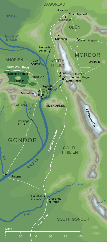
The name given to the road that ran southwards from Mordor's Black Gate, skirting the western edges of Ephel Dúath as it passed though North Ithilien. Near the entrance of Imlad Morgul it met the old east-west road that connected Osgiliath with Minas Ithil, at a place known simply as the Cross-roads. From there, the road ran on through South Ithilien, past the hills of Emyn Arnen, and eventually reached the Crossings of Poros far to the south. From there, the Harad Road led on further, into the depths of the southern lands of the Harad.
Notes
1 |
The origins of the Southward Road are not explained in detail, but we are told that it was the 'handiwork of Men of old', and had been 'made in a long lost time' (The Two Towers IV 4, Of Herbs and Stewed Rabbit). Men would hardly have needed to travel to the Black Gate before the War of the Last Alliance, so the implication is that the road was made after that War. It would have formed part of the guard placed by Gondor on Mordor, as well as providing a useful route through Ithilien.
|
2 |
It might seem strange that the same road could be known as both the 'Southward Road' and the 'North Road', but the names came from different perspectives. For those following the road from the North (as Frodo did from the Morannon) this was the Southward Road, but to one travelling northward out of Gondor towards the Morannon, this was the North Road.
|
Indexes:
About this entry:
- Updated 24 February 2024
- This entry is complete
For acknowledgements and references, see the Disclaimer & Bibliography page.
Original content © copyright Mark Fisher 2008, 2023-2024. All rights reserved. For conditions of reuse, see the Site FAQ.
Website services kindly sponsored by myDISCprofile, the free online personality test.
How do your personal strengths fit in with career matching? How can you identify them? Try a free personality test from myDISCprofile.