- Cities and buildings
- Fields, plains and deserts
- Forests
- Hills and mountains
- Islands and promontories
- Lands, realms and regions
- Rivers and lakes
- Seas and oceans


 |
||||||||||
|


Which personality type are you?
Take the Free mydiscprofile Personality Test to discover your core personality and your ideal job.   Which personality type are you? |
|
Dates
Location
In Ephel Dúath, in the pass of Cirith Ungol
Settlements
Lay close to the Tower of Cirith Ungol
Passes
Pronunciation
Shelob is probably pronounced 'shee'lob'3
Meaning
Other names
Indexes: About this entry:
|
Shelob’s LairThe dark tunnels of Cirith Ungol
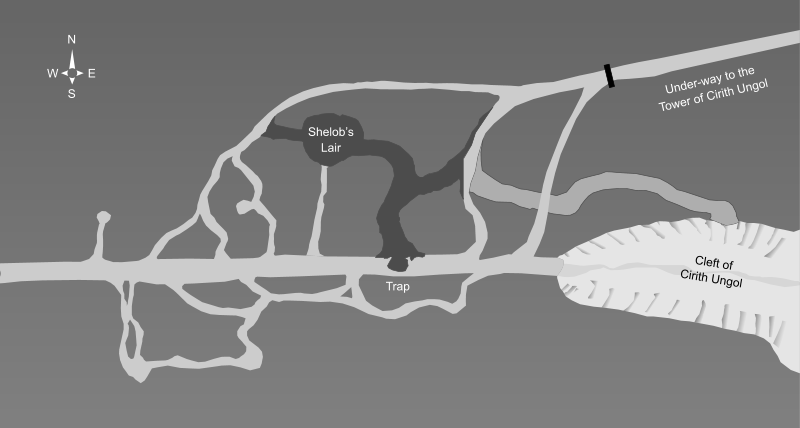
The general layout of Shelob's Lair4
The general layout of Shelob's Lair4
A partial English translation of Torech Ungol, the name of the black, mazelike lair of Shelob in the pass of Cirith Ungol. Notes
See also...Cirith Dúath, Evening Star, Galadriel, Gnats, Gollum, Her Ladyship, High Pass, Phial of Galadriel, Straight Stair, The Watcher, Under-way, Undergate Indexes: About this entry:
For acknowledgements and references, see the Disclaimer & Bibliography page. Original content © copyright Mark Fisher 1999, 2000, 2019, 2022. All rights reserved. For conditions of reuse, see the Site FAQ. Website services kindly sponsored by myDISCprofile, the free online personality test.How do your personal strengths fit in with career matching? How can you identify them? Try a free personality test from myDISCprofile. |