- Cities and buildings
- Fields, plains and deserts
- Forests
- Hills and mountains
- Islands and promontories
- Lands, realms and regions
- Rivers and lakes
- Seas and oceans


 |
||||
|


Which personality type are you?
Take the Free mydiscprofile Personality Test to discover your core personality and your ideal job.   Which personality type are you? |
|
Dates
This region was probably inhabited from the time of the Great Journey (long before the first rising of the Sun), though this is uncertain
Location
The point of land between the Great River and Celebrant (or Silverlode), forming the southeastern part of Lórien
Race
Division
Peopled primarily by Silvan Elves
Culture
Settlements
Meaning
'Sharp point' (in reference to its shape)
Other names
Indexes: About this entry:
|
The GoreThe secret heartland of Lórien
The Gore of Lórien (somewhat conjectural)
The Gore of Lórien (somewhat conjectural)
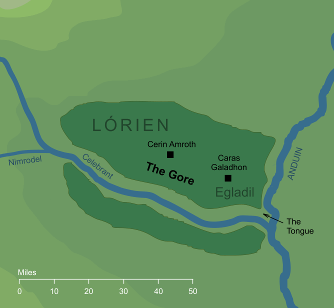
Haldir's translation of the Elvish name Naith, referring to the long pointed region of Lórien that lay between the river Silverlode and the Great River Anduin. 'Gore' is an old word, essentially meaning 'sharp point'. Its etymology goes back in time to Old English gāra (a word for a narrow triangular piece of land) so Haldir's translation is a very precise one. It was within the Gore that most of the Galadhrim, the Silvan people of Lórien, dwelt. For the most part, the habitations of the Elves were to be found in the narrow southerly point of the Gore, where it approached the Angle between the two rivers.1 Galadriel's power of preservation, granted her by the Elven-ring Nenya, extended over the land of the Gore, so that crossing the Silverlode (or Celebrant, as the Elves named that river) into the Gore gave one the feeling of stepping into a different time. Few outsiders experienced this curious effect, however, as the Galadhrim were protective of their land, and allowed few strangers to visit the heartland of Lórien. The maps included with The Lord of the Rings don't seem to closely match the description of the Gore as being narrow and spear-shaped. Rather, those maps show the land of Lórien as having a relatively rectangular form. Tolkien acknowledged this in a note reproduced in Unfinished Tales, where he says that '...the actual junction of the rivers was narrower and more pointed than can be shown on a small-scale map.' (Unfinished Tales Part Three I, The Disaster of the Gladden Fields, Note 16). While the map shows the Silverlode flowing into Anduin in an approximately eastward direction, the implication here is that it actually ran more toward the southeast, creating a longer and narrower stretch of woodland between the rivers than appears on the map. Notes
See also...Indexes: About this entry:
For acknowledgements and references, see the Disclaimer & Bibliography page. Original content © copyright Mark Fisher 2005, 2016, 2023. All rights reserved. For conditions of reuse, see the Site FAQ. Website services kindly sponsored by Discus from Axiom Software Ltd.Thousands of clients worldwide rely on Discus DISC profiles for their personality profiling needs. |