Dates
Cuiviénen belongs to very ancient times far back in the Years of the Trees - it no longer exists, or at least cannot be found. Location
The distant east of Middle-earth, on the eastern shores of the Sea of Helcar. Race
Important peaks
The range of the Orocarni ran to the east of Cuiviénen Pronunciation
kuivi'aynen ('ui' as in English 'ruin')
Meaning
Other names
Indexes:
About this entry:
- Updated 6 June 2004
- Updates planned: 2
|

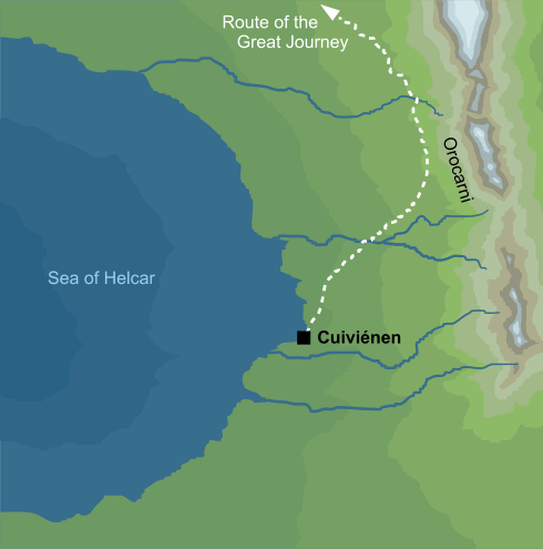
This map of Cuiviénen is adapted from Map IV from The Shaping of Middle-earth (volume IV of The History of Middle-earth). It is unclear how much of that geography Tolkien meant to stand, but it is the only source we have that shows Cuiviénen in any detail. Certain elements of the map shown here have been modified to bring it into line with the published Silmarillion - see Note 1 for details.
This map of Cuiviénen is adapted from Map IV from The Shaping of Middle-earth (volume IV of The History of Middle-earth). It is unclear how much of that geography Tolkien meant to stand, but it is the only source we have that shows Cuiviénen in any detail. Certain elements of the map shown here have been modified to bring it into line with the published Silmarillion - see Note 1 for details.
Called the Water of Awakening, the land on the shores of the inland sea of Helcar where the first Elves awoke during the Years of the Trees; it lay far in the east of Middle-earth.
Notes
1 |
The original Map IV shows four great mountain ranges, arranged symmetrically across Middle-earth: the Blue, Red, Grey and Yellow Mountains. The mountains associated with Cuiviénen are marked as the northeastern range, the Red Mountains. That term never appears in The Silmarillion, but there is a reference there to a range known as the Orocarni near Cuiviénen. Orocarni is Elvish for 'Red Mountains', so the map above assumes the two terms are equivalent, and uses the later form. (Of the other three great ranges, the Blue Mountains in the northwest survived to appear in The Lord of the Rings, but the Grey and Yellow chains in the south disappeared into obscurity.)
Tolkien's original map shows no rivers or streams of any kind. However, The Silmarillion tells us that 'Many waters flowed down thither [to Cuiviénen] from heights in the east...' (Quenta Silmarillion 3). Accordingly, several streams or rivers have been added to the map, though it should be noted that the number and location of these is purely speculative.
The old Map IV shows the Sea of Helcar as essentially a regular ellipse, with Cuiviénen on its eastern shores. However, The Silmarillion says that there was a bay in the Sea at Cuiviénen's location. While there are no bays or inlets marked on the original Map IV, then, a shallow bay has been added in the version shown above. |
See also...
Aman, Angainor, Araw, Belegurth, Dark Elves, Dwarves, Edhil, Eldar, Eldar of the West, Elentári, Elu Thingol, Elves, Elves of the High Kindred, Elves of the Light, Elvish World, [See the full list...]Forester, Great Journey, Great Rider, Great Sea of the West, Helluin, High Folk of the West, High King of the Noldor, Huntsman of the Valar, Inland Sea of Helcar, Laiquendi, Lenwë, Lindar, Lord of Beleriand, Menelmacar, Middle-earth, Misty Mountains, Mountains of the East, Noldor, Orocarni, Oromë, Outer Lands, People of the Great Journey, Powers of the World, Quendi, Rhûn, Tauron, Teleri of Valinor, The East, The Hunter, The Rider, The Unwilling, Third Clan, Two Kindreds, Vanyar, War of the Powers, Water of Awakening, Wide World, Wild Wood, Years of the Trees
Indexes:
About this entry:
- Updated 6 June 2004
- Updates planned: 2
For acknowledgements and references, see the Disclaimer & Bibliography page.
Original content © copyright Mark Fisher 1998, 2001, 2004. All rights reserved. For conditions of reuse, see the Site FAQ.
Website services kindly sponsored by Axiom Discovery aptitude and skill testing.Axiom Discovery gives you comprehensive online aptitude testing covering core skills across a wide range of disciplines.
|

