The Encyclopedia of Arda - an interactive guide to the world of J.R.R. Tolkien
Dates
Founded no earlier than the settlement of the Shire in III 16011
Location
Race
Culture
Family
Associated with the Bolgers
Pronunciation
bu'dgeford
Meaning
Budge- is somewhat obscure, but seems to derive in part from 'Bolger'2; -ford refers to the village's location at a ford across the Water

Indexes:

About this entry:

  • Updated 14 August 2017
  • This entry is complete

Budgeford

A town of the Shire’s Eastfarthing

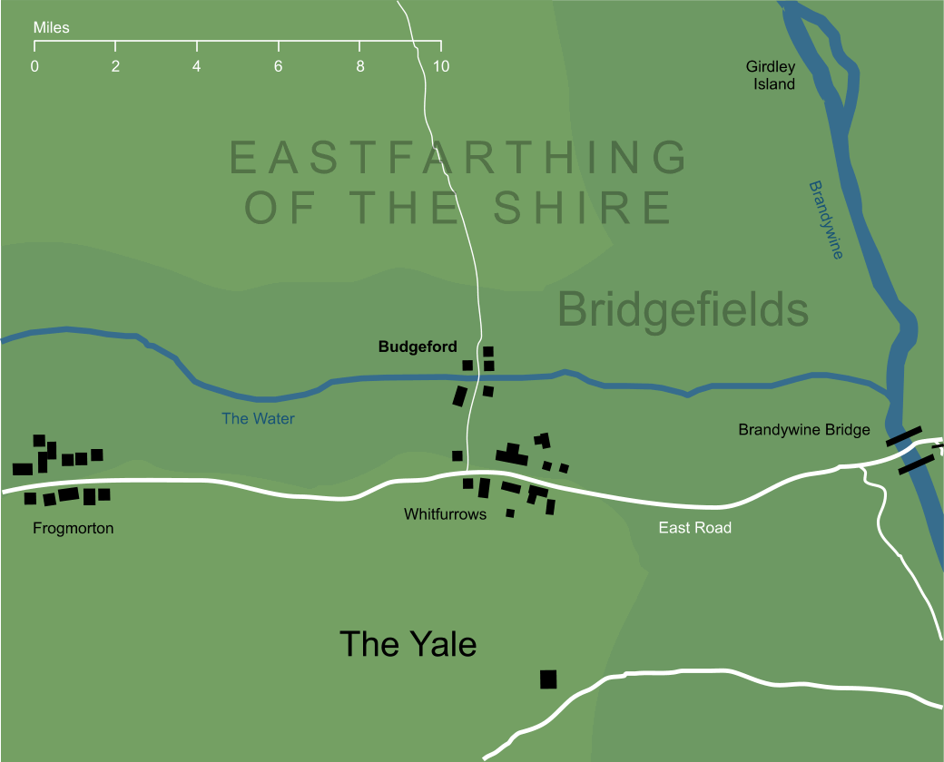
Map of Budgeford
Slightly conjectural3

A settlement in the eastern part of the Shire, so close to the Brandywine Bridge that it fell in the district known as Bridgefields. It lay on the tributary of the Brandywine known simply as the Water. The 'ford' in its name apparently derives from a ford across this stream (though the 'Budge' element is obscure, and intentionally so, according to Tolkien). The town of Budgeford was the seat of the Bolgers, an important family among the Shire-hobbits.


Notes

1

The first Hobbits to enter the Shire did so from the east, across the Brandywine Bridge (or the Bridge of Stonebows, as it was then known). As one of the closest villages to that Bridge, we might speculate that Budgeford was one of the earlier settlements of the Shire-hobbits.

2

In his Guide to the Names in The Lord of the Rings, Tolkien says that Budge- '...was an obscured element, having at the time no clear meaning.' He does however suggest that it might be a corrupted form of bolge or bulge, connecting it with the Bolger family (so that the full name 'Budgeford' would simply mean 'Bolgers' ford'). It might conceivably have been influenced by Old English budda, a word that literally meant 'beetle', but was also used jocularly to mean 'tubby'.

3

Reproducing the geography of Budgeford presents some minor difficulties. With a name containing 'ford' we might expect it to be associated with a river crossing, and indeed Tolkien confirms this in his unfinished index to The Lord of the Rings, calling it a 'village by a ford over the Shire-water in Bridgefields'. The large-scale map of the Shire indeed shows a crossing of the Water marked 'Budge Ford' in the area known as Bridgefields, so fixing its location should not in principle be problematic. The same map, however, fails to show any kind of settlement in that location, and based purely on that source, the natural conclusion would be that 'Budge Ford' was no more than a crossing of the Water. It is clear from other references, however, that Budgeford was indeed a village, and one that was important enough to be the seat of the Bolger family. The dwellings around the ford shown on this map have been added to make its status as a settlement clear, but note that these buildings do not appear on the original Shire map.

It seems marginally possible that there might be some confusion of labelling at work here, as there is a larger settlement on the East Road not far south of the ford that might potentially represent Budgeford. The labels on the Shire map seem to identify this small town fairly definitely as 'Whitfurrows', but the arrangement of labels might conceivably make this larger village Budgeford, with Whitfurrows a smaller connected hamlet. This rather awkward reading of the map, however, would place Budgeford some three miles from the ford of its name, and therefore seems implausible.

Indexes:

About this entry:

  • Updated 14 August 2017
  • This entry is complete

For acknowledgements and references, see the Disclaimer & Bibliography page.

Original content © copyright Mark Fisher 2004, 2010, 2017. All rights reserved. For conditions of reuse, see the Site FAQ.

Website services kindly sponsored by Discus from Axiom Software Ltd.
Whatever your personality profiling needs, Discus has a solution for you.
The Encyclopedia of Arda
Menu
Homepage Search Latest Entries and Updates Random Entry