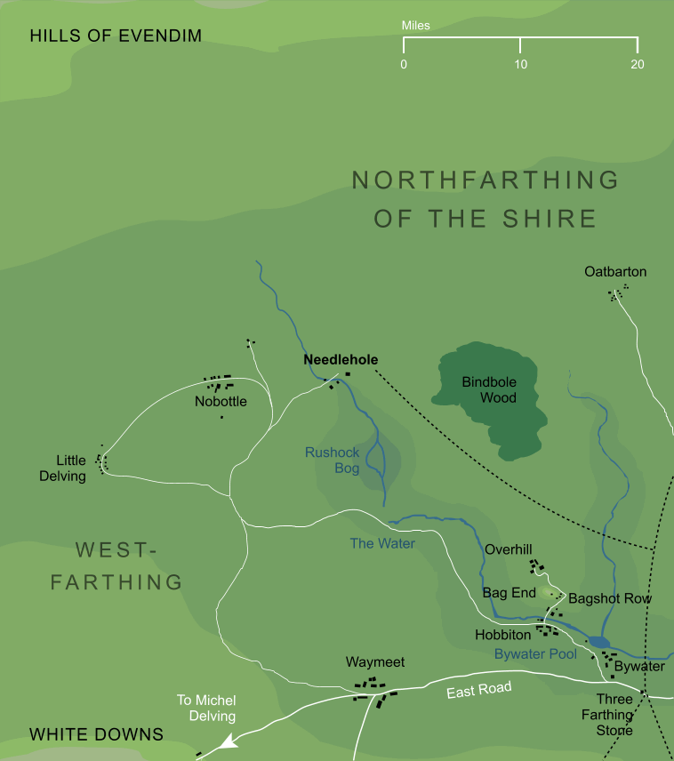
Needlehole and surrounding area (somewhat conjectural)2
Needlehole and surrounding area (somewhat conjectural)2
A small village in the remote northwestern parts of the Shire. It lay strictly within the Westfarthing, but only a few miles from the borders of the Northfarthing. It had few neighbouring settlements, apart from the village of Nobottle to the west. Probably its nearest town of any size was Waymeet, some thirty miles to the south. Needlehole was connected to Waymeet by a winding a circuituous road, whose wide loops were in part required to avoid Rushock Bog, directly to the south of Needlehole village.
Notes
1 |
Needlehole in the Shire was perhaps inspired by the tiny hamlet of the same name in Gloucestershire, England. The origins of the name are uncertain, but it appears to have derived from 'Needle's hole' (that is, 'Needle' was personal name). In the context of the Shire, the 'hole' would presumably refer to a Hobbit-hole, which was apparently occupied at some point by a Hobbit known as 'Needle'.
|
2 |
Needlehole lies near the northwestern edge of the part of the Shire that is mapped in detail. Northward of this village, and westward of nearby Nobottle, we have little definite geographical information. In particular, the location of Little Delving is estimated here based mainly on the arrangement of roads in the area. While it was known to have been in this approximate area, it may not have stood precisely at the point that it is shown on this map.
|
Indexes:
About this entry:
- Updated 7 May 2021
- This entry is complete
For acknowledgements and references, see the Disclaimer & Bibliography page.
Original content © copyright Mark Fisher 2006, 2021. All rights reserved. For conditions of reuse, see the Site FAQ.
Website services kindly sponsored by myDISCprofile, the free online personality test.
Explore the benefits of using a personality profile to discover yourself and make the most of your career.

