- Cities and buildings
- Fields, plains and deserts
- Forests
- Hills and mountains
- Islands and promontories
- Lands, realms and regions
- Rivers and lakes
- Seas and oceans


|
||||
|


Which personality type are you?
Take the Free mydiscprofile Personality Test to discover your core personality and your ideal job.   Which personality type are you? |
|
Location
Origins
Presumably the result of ash cast out by Orodruin
Races
Ruled by one of the Ainur
Division
Settlements
Barad-dûr stood on the western edge of Lithlad
Pronunciation
l'ithlad
Meaning
'Plain of ash'
Indexes: About this entry:
|
LithladMordor’s northern plain of ash
Somewhat conjectural1
Somewhat conjectural1
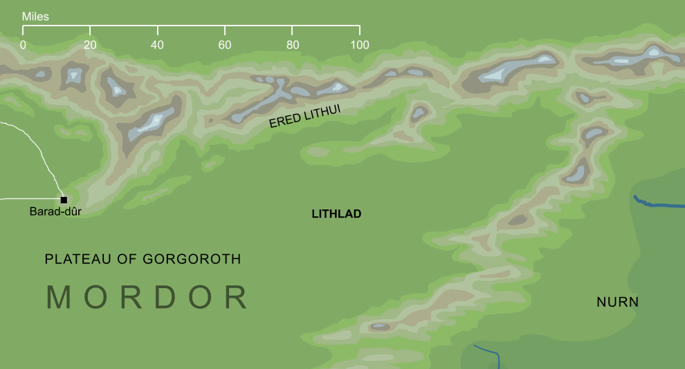
A plain that lay in the north and east of Mordor, connected to the Plateau of Gorgoroth. The name Lithlad means 'plain of ash', suggesting that it was strewn with the ashes of the Fire-mountain Orodruin that lay to its west (though the name may also be connected to Ered Lithui, the Ashen Mountains that formed Lithlad's northern border). The precise location and dimensions of Lithlad are rather indefinite, though we know that it lay to the east of Barad-dûr, and it seems to have represented the eastern parts of Mordor's northern plateau, above the point where that land descended into the more fertile lowlands of Nurn. Notes
See also...Indexes: About this entry:
For acknowledgements and references, see the Disclaimer & Bibliography page. Original content © copyright Mark Fisher 2002, 2010, 2014. All rights reserved. For conditions of reuse, see the Site FAQ. Website services kindly sponsored by Discus from Axiom Software Ltd.A Discus profile report contains more than sixty pages of detailed and relevant information - explore our library of sample DISC reports. |